Isle Royale & The Treaty of Paris
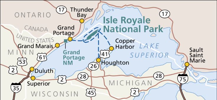
I started my research for today’s journal entry to answer the question: Why is Isle Royale in Michigan? This Lake Superior island is, after all, about 55 miles from Michigan shore. It is far closer to Ontario (about 22 miles) and to Minnesota (about 17 miles). So why is it in Michigan?
Although I did a fair amount of research, I still don’t know why. But I do know when or at least when it became American and not British (and ultimately Canadian).
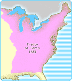
The when, surprisingly, was 1783, with the Treaty of Paris which ended the American Revolution. (Sidenote: I wonder if I am the only person who has read the Treaty of Paris in the least hundred years.)
The complete story is in the pdf link below.
2021 Update
I found an old map in my stuff not too long ago. It is a reproduction of a 1755 French map of the Great Lakes. I framed it and it is now hanging on one of my walls.

I hadn’t noticed until I hung the map that it had two large islands on Lake Superior – Isle Royale and Isle Phelipeaux. I’ve been on Lake Superior and I’ve seen modern maps, and I know there is only one large island over there. It is Isle Royale. Isle Phelipeaux doesn’t exist. I pondered this awhile and presumed that French explorers made a mistake. One group of explorers canoed around an island, noted its location, and called it Isle Royale. Another group canoed around the same island, noted its location, and called it Isle Phelipeaux. The two groups described the island’s location differently, so map makers assumed they found two different islands. That is my theory. The drafters of the Treaty of Paris of 1783 might have used the same map, or at least a similar one, since the treaty awarded both Isle Royale and Isle Phelipeaux to the United States. You can see the two different islands on the map above.
When I reposted this Wolverine Café journal, I was reminded of the Treaty of Paris’ reference to Isle Phelipeaux. I did a modest amount of research, and it turns out my theory was correct. The mistake wasn’t discovered until 1820, when the border between the United States and Canada was further surveyed.